


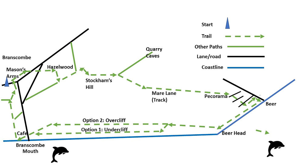
22. East Devon Coastal: Branscombe to Beer (circular) - 6 miles (7 if you start from Branoc Hall) - O/S map Landranger 192
- Jan 26, 2022
- 7 min read
Updated: Jun 27, 2024
Steep in parts, every inch lovely.

There are few more satisfying walks than this. Great views, great pubs, plenty of tea houses and fine pebble beaches.
Driving in from the west, you’ll pass The Fountain Head on your right, an old-fashioned stone floored pub serving superb local ales and home-cooked food. Walk in to get transported back in time (parking at the rear). But don’t stay too long, you’ve got a walk to do. Drive further down (it’s supposedly the longest village in England, although this bit is really Street) and park just before the Mason's Arms.

If no spaces, don't worry, go back the way you came a little way to Branoc Hall. There you can park for free, but they'd appreciate a donation in (cute of cutes) the wishing well.
Parking here brings the bonus of a cuppa at the medieval bakery opposite, which is not cute but utterly charming, as is much of Branscombe.
After leaving the cafe, turn right and right again, signposted to the Mill. Passin it, don't turn into it but carry straight on past grazing sheep until the path diverges. Take the path signposted to the Masons arms .
It's another fine pub, but as different as caviar and pork pie from the Fountain Head. Think squires here and us forelock tuggers at the other place.
Keeping straight ahead, the lane starts to climb steeply. After a hundred yards or so, Just before a right turn into another lane, go right, up a path with a wooden rail that joins that lane. Cross over to the path ahead.

Signposted Stockham’s Hill, this path is an uphill slog with a lovely whiff of wild garlic in season. Enjoy too, the lovely view through trees down to Branscombe.
Crossing over a stile, go left and continue climbing, ignoring another stile on your left in favour of the stile that brings the path out of woodland into a field. Go left again.
At the end of the field, go through a farm gate into the next and, rather than follow the signpost pointing ahead, take a 30-degree diagonal to the right which brings you to another farm gate.

Now it’s straight ahead on a farm track leading to Mare Lane, an ancient, high hedged unmetalled track. It's a reminder of how awful Devon’s roads used to be. So bad that pack-horses were the normal form of travel. If something was too heavy for them, like local stone from nearby Beer quarry, it was hauled by oxen and sled. For much of Devon, wheels were useless until turnpikes forced travellers to pay tolls for road improvements in the latter half of the 18th century). Cornwall Celts can thank Devon for making life difficult for invaders.

An attractive limestone, Beer Stone was used on many local buildings, including Exeter Cathedral. Local Romans also favoured it for their villas. It was even used for London’s St. Pauls Cathedral. That’s a long way on runners. Now the underground quarry is a tourist attraction well worth a visit for its interesting history and spooky atmosphere.
Another tourist attraction is Pecorama, a miniature railway museum and play park. I can take or leave trains, but my grandkids loved it, and so might you - and it’s where Mare Lane as a rutted track ends and turns into dull suburban road.

Leaving Pecorama behind, turn left and look out for a footpath sign a few yards down and over the road by Abbey Lodge. Where this path meets another road, dogleg left then right down another path. This comes out a by a graveyard on Clapp’s Lane. Check out the local stone on the wall that surrounds the graveyard: Beer stone and flint. There’s so much flint in this area, a nice little earner to supplement the fishing and quarrying, was chipping it into tiny fragments for muskets. No doubt they flogged them to customs men and smugglers alike - and stood well back.

Turning left down Clapp’s Lane brings you to Fore St. On the corner is The Dolphin Hotel. If you like bric a brac and the odd treasure, there’s an antique centre in the car park.
Hugging your 1982 Blue Peter Annual find - the one you used to hide your racy magazines in when you were a pimpled youth - turn right down Fore St and enjoy the rather well-to-do feel of Beer. I told you chipping flint was a nice little earner. Or was it the quarrying?

Fore St. ends dipping steeply to the beach, the open water channel at its side making a final sprint to the sea. On your left, before you step onto the pebbles with its fishing boats, winches and piled high crab and lobster pots, is an excellent fishmonger flogging today’s catch.
If you prefer catching your own, small motorised self-drive clinker-built boats are for hire in summer. Alternatively, the skipper of Little May (see first pic.) will take you out for a fee, - and he knows where the mackerel are.

Depending on how you look at it, Beer is where the White Cliffs Vera Lynn warbled about starts or ends. Like Dover, there are no bluebirds but plenty of elegant, but noisy, gulls. Love ‘em or hate ‘em, it’s still a glorious bay and beach, full of old-world character. It’s hard to fathom why next-door Seaton is so drab by comparison.
Finished relaxing on the beach, head back toward Fore St. and turn left up Common Lane by the Anchor Inn. I’ve had some great fish lunches in the Anchor's beer garden that overlooks the beach. The perfect setting, although it can be hard to find a seat in the high season.

Continuing up the hill by allotments, keep an eye out for the coastal path sign before you reach the large car park. If you thought the walk was lovely up to now, it only gets better. Leaving a caravan park behind there are marvelous views along the coast to your left, often as far as Portland Bill in Dorset. Aptly named – think duck's bill – it’s easy to spot.
Passing Beer Head, you’ll come to a signpost pointing straight ahead to Hooken cliffs, and left to Branscombe Mouth. Actually, they both lead to Branscombe Mouth. Here’s the dilemma: both trails are magnificent. The only reasonable solution is to set aside a future date to do the walk again to experience both the over-cliff and under-cliff options. I’m lucky, I live near enough to do this walk regularly.

Option 1: Turn left onto the trail through the under-cliff. Admire the views and take a moment to explore close-up an outcrop of chalk encrusted with flint on your left. About here, the chalk turns to sandstone. Looking ahead, you’ll see a cave set high up in those cliffs. As you descend through trees and shrub, you’ll come across a path on the right that leads to it. Worth a peek but, unless you’re an experienced climber, don’t be tempted to climb up; not even if someone’s been up there and left a rope dangling. You don’t know how well it’s secured. Frankly, the cave is less fascinating than it looks from the outside, and doesn’t go very far in.

Eventually the path nears the beach and there are a couple of cuttings down onto it. Your choice whether you go on to Branscombe Mouth by the beach or on the path. I prefer the path and its little grottos and root-and-rock surprises.
Assuming you follow the path, it comes out at The Sea Shanty Caravan Park, an excruciatingly twee name for a collection of huts and caravans set in the under-cliff with fabulous sea views. If I wasn’t a local, this is where I’d want to stay, despite the name. It’s lovely here.
Exiting the caravan park, this is where you would have met yourself if you’d done a metaphysical split and done option 2 at the same time.

Option 2: Rather than exploring the under-cliff, stay on the cliff top. Ahead is an old lookout tower that had been transformed into a ramshackle home – or maybe second home. It’s currently (10.1.22) undergoing a transformation into something plusher. I don’t know why I think that’s a pity.
Passing the tower and the grazing sheep that sometimes surround it, the clifftop starts to descend to Branscombe Mouth. The views down to the village and beach are stunning – a word that doesn’t seem sufficient for a coastline with lots of stunning views. Anyway, enjoy it while slip-sliding your way on a sometimes-muddy path until you reach the entrance to the caravan park where your other self is waiting.

From the Caravan Park entrance, carry on down toward Branscombe Mouth, ignoring paths to the right. Tucked into shrubbery, look out for the WWII bunker to your left. This coastline is where Churchill and his mates thought the invasion might come, and there are dozens of others bunkers roundabout. In fact, from Seaton to the north coast there's a line of them. Had this been 1942, from Seaton westwards could have been German controlled while the rest of the country fought to keep them from going further east. Back in the 7th century it was the Dumnonii – a Celtic tribe from which the roots of the name Devon came – trying to stop Anglo Saxons moving west, and then in the 11th century it was the Norman’s shoving the Anglo Saxon’s out. Devon has a history of being a punch bag and fire-screen, west and east.

Time for an ice cream from the pretty café beachside at Branscombe Mouth? It’s local! Checkout the anchor in front of it. It's from the Napoli, a container ship that came to grief on a sandbank nearby and shed its load into the sea.
It wasn't a pretty sight watching scavengers on TV fighting over the spoils washed up on the beach here, including peoples personal possessions. The village was log-jammed the for days. I went to look a week or so later. There were almost as many soggy polish bibles as pebbles lying aBounT. All gone now tho, apart from the anchor.

Passing the café, turn immediately right by the side of it. Ahead is a pleasant wooded walk by a stream.
Woodland turns to farmland. After crossing a couple of wooden footbridges, turn right to return to Branscombe, the Mason’s Arms, and your car.
If you're not the driver, a pint by the Mason's roaring fire in a big hearth would be a pleasant way to finish the walk. There's a bench right by it.


Comments